- Drivers site
- Toll / road information
- Road overview
- E76 Nishi-Seto Expressway (Setouchi Shimanami Expressway)
E76 Nishi-Seto Expressway (Setouchi Shimanami Expressway)
A road crossing the Geiyo islands
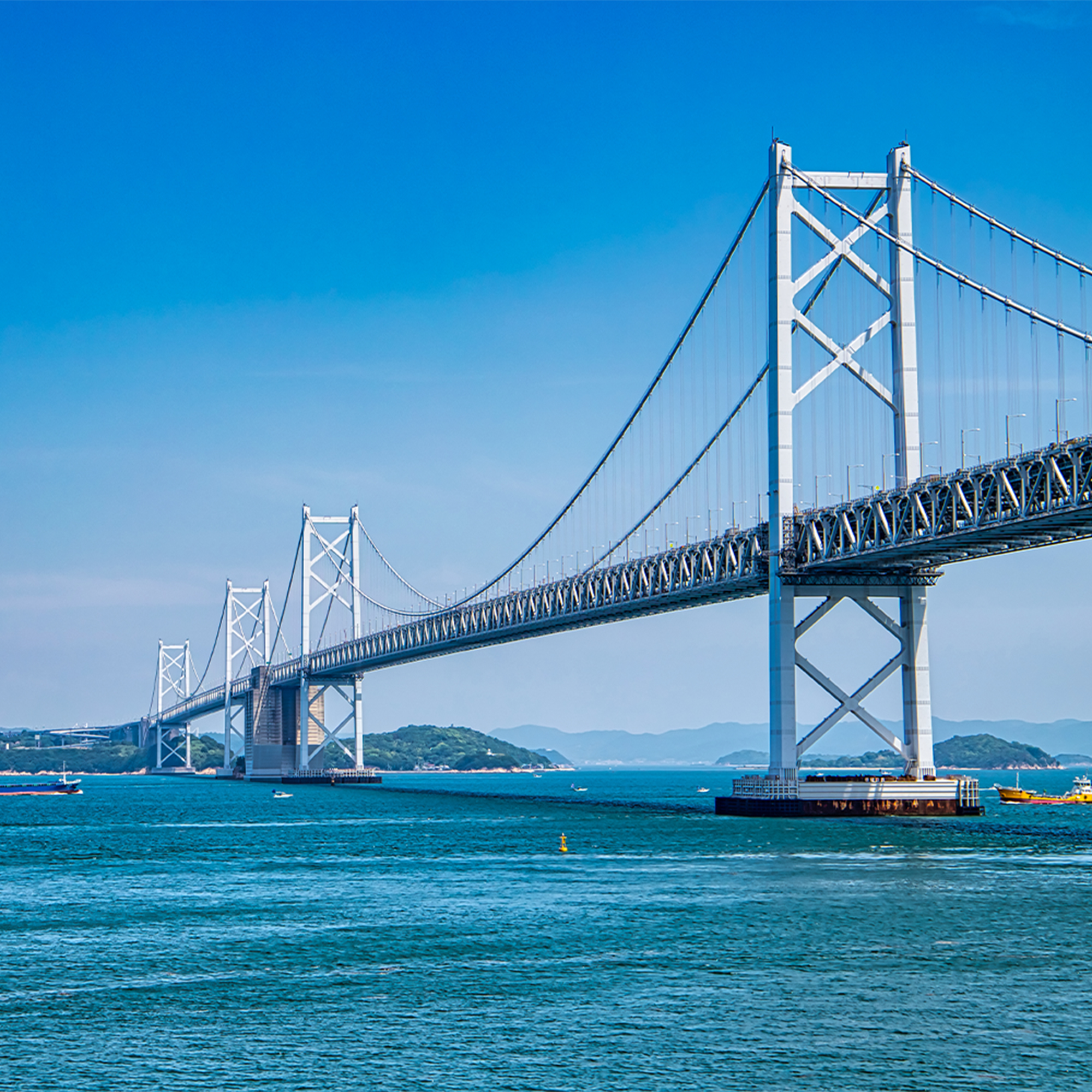
A 46.6km toll road that threads its way through the Geiyo Islands where the "Murakami Pirates", the strongest in the Seto Inland Sea, once had brave adventures. This expressway, with a total length of 59.4 km directly connected with the Ikuchi-jima road (6.5 km) and the Ohshima road (6.3 km) maintained by Ministry of Land, Infrastructure, Transport and Tourism, is affectionately known as the "Setouchi Shimanami Expressway". On bridges other than the Shin-Onomichi Bridge, there is also tracks exclusively for use by motor-assisted bicycles and pedestrians from Onomichi to Imabari, and as well as its role as a connecting road linking Honshu and Shikoku, it serves a major role as a community road for the people living on the islands.
| Details | Between Nishi-Seto Onomichi IC and Ikuchijima-Kita IC |
|---|---|
| 1. Route name | National Route 317 |
| 2. Section in operation | From: 1219-10, Aza-Saigakubo, Takasu town, Onomichi city, Hiroshima Pref. (Nishiseto-Onomichi IC) To: 580-2, Aza-Fukakubo, Innoshima-Sunoe town, Onomichi city, Hiroshima Pref. (Ikuchijima-Kita IC) |
| 3. Length | 18.0km |
| 4. Construction costs | Approx. 37 billion yen (Shin-Onomichi Bridge-related section) Approx. 68 billion yen (Innoshima Bridge-related section) Approx. 44 billion yen (Ikuchi Bridge-related section) |
| 5. Start of service | December 4, 1983 Between Mukaihigashi Ramp and Innoshima IC December 8, 1991 Between Innoshima-Minami IC and Ikuchijima-Kita IC April 1, 1998 Between Ikuchijima-Kita IC and Innoshima-Minami IC March 13, 1999 Nishiseto-Onomichi IC and Onomichi Ohashi Ramp (4 lanes) May 1, 1999 Onomichi-Ohashi Ramp and Mukaihigashi Ramp |
| 6. Service status | National Highway with access control Motorized bicycle, bicycle and pedestrian way Mukaihigashi Ramp Disused on May 1, 1999 when all portions were put in service |
 |
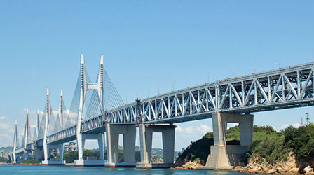
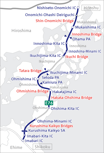
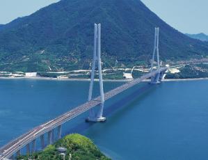
Shin-Onomichi Bridge (Completed in 1999) Cable stayed bridge (Total length: 546 m, Center span: 215 m) |
|---|---|
 |
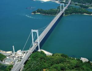
Innoshima Bridge (Completed in 1983) Suspension bridge (Total length: 1,270 m, Center span: 770 m) |
 |
Ikuchi Bridge
(Completed in 1991) Cable stayed bridge (Total length: 790 m, Center span: 490 m) |
| Details | Between Ikuchijima-Minami IC and Ohshima-Kita IC |
|---|---|
| 1. Route name | National Route 317 |
2. Section in operation |
From: 986, Aza-Hosenbara, Ogi, Setoda town, Onomichi city, Hiroshima Pref. (Ikuchijima-Minami IC) |
3. Length |
16.1km |
4. Construction costs |
Approx. 130 billion yen (Tatara Bridge-related section) |
5. Start of service |
May 13, 1979 Between Ohmishima IC and Hakatajima IC |
6. Service status |
National Highway with access control Motorized bicycle, bicycle and pedestrian way |
 |
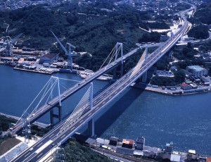
Tatara Bridge (Completed in 1999) Cable stayed bridge (Total length: 1,480 m, Center span: 890 m) |
|---|---|
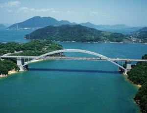 |
Ohmishima Bridge (Completed in 1979) Arch bridge (Total length: 328 m, Center span: 297 m) |
 |
Hakata-Ohshima Bridge (Completed in 1988) Hakata Bridge: Steel box girder bridge (Total length: 325 m, Center span: 145 m) Ohshima Bridge: Suspension bridge (Total length: 840 m, Center span: 560 m) |
| Details | Between Ohshima-Minami IC and Imabari IC |
|---|---|
| 1. Route name | National Route 317 |
2. Section in operation |
From: 3614-1, Myo, Yoshiumi town, Imabari city, Ehime Pref. (Ohshima-Minami IC) |
3. Length |
12.5km |
4. Construction costs |
Approx. 330 billion yen (Kurushima-Kaikyo Bridges-related section) |
5. Start of service |
May 1, 1999 Between Ohshima-Minami IC and Imabari IC |
6. Service status |
National Highway with access control Motorized bicycle, bicycle and pedestrian way |
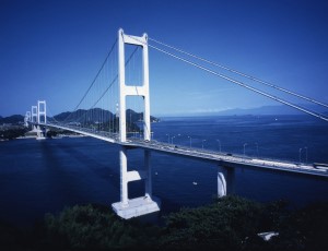 |
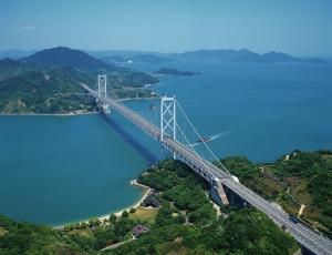
Kurushima-Kaikyo Bridges (Completed in 1999) 1st Kurushima-Kaikyo Bridge: Suspension bridge (Total length: 960 m, Center span: 600 m) 2nd Kurushima-Kaikyo Bridge : Suspension bridge (Total length: 1,515 m, Center span: 1,020 m) 3rd Kurushima-Kaikyo Bridge: Suspension bridge (Total length: 1,570 m, Center span: 1,030 m) |
|---|
See here for Shimanami Expressway sightseeing and event information
 |
You can see an introduction to the Shimanami Expressway (Nishi-Seto Expressway), sightseeing and event information, and blogs by staffs working for the Shimanami Expressway. |
|---|